Tithe Maps. Tracing the First Chapter of Your Home’s Story
When we begin researching a home, we often start with the familiar records. Census returns, electoral registers, old photographs and perhaps a few stories passed from one owner to the next. These are valuable pieces of the puzzle. Yet to understand the true beginnings of a property, there is one resource that offers an unparalleled glimpse into the landscape before modern development. The tithe map and its accompanying apportionment.
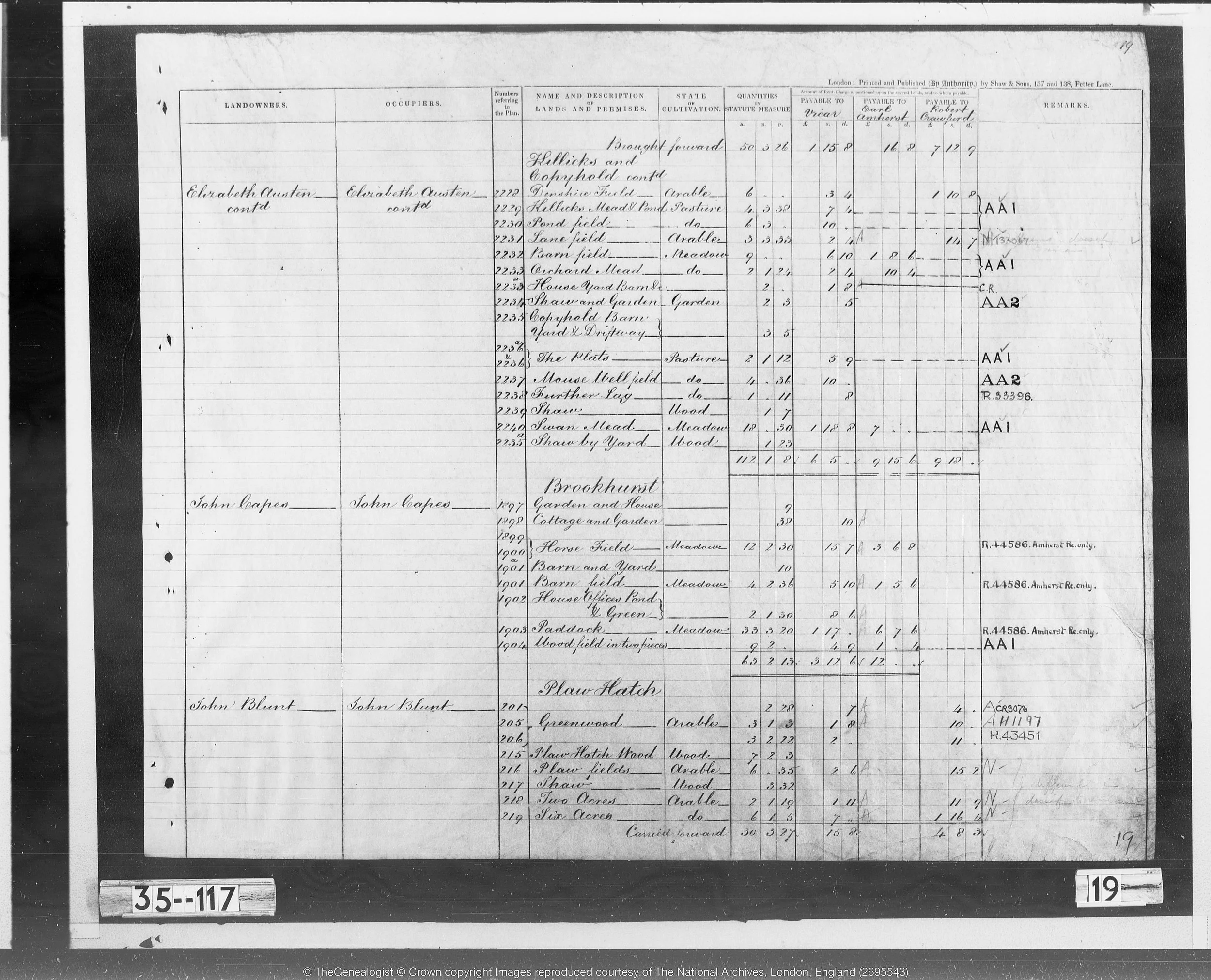
An example of a Tithe Appportionment - showing the owners and types of land in question.
Created from the 1830s to the 1850s, tithe maps were produced during a nationwide reorganisation of the tithe system. To ensure fair payment, surveyors recorded every field, cottage, yard and meadow within a parish and noted who owned it, who occupied it and how it was used. The result is one of the most detailed surveys of rural England in the nineteenth century.
For house history research, tithe maps are invaluable. They reveal what the land looked like long before streets were laid out, before estates were divided and often before the first house on the site was even imagined. A modern property might sit on a plot once described as orchard, meadow or pasture, and the tithe apportionment will name the landowner, the occupier and the size of the parcel with remarkable precision. These records allow us to match modern homes to their historic footprints and uncover the landscape that came before them.
Tithe maps are especially important because they predate the Land Registry. Many properties were not registered until the late twentieth century, leaving early ownership obscure or entirely undocumented. Tithe records help bridge this gap. They identify the estates, families and individuals who controlled land in the early nineteenth century and show how that land was managed and divided. For many homes, they provide the earliest firmly anchored point in the documentary record.
What makes tithe maps so compelling is their ability to place a home within its historic setting. They show the shape of the land, the pattern of fields and the relationship between farms, cottages and early roads. They remind us that every home sits within a much older story and that long before the present building stood, the land itself had a life of its own.
If you are curious about the earliest chapter of your home’s history, tithe maps are often the perfect place to begin and copies can be found at the National Archives in Kew.
To discover what the land beneath your home once was, and to uncover the story of the people who shaped it, you can order one of our house history packages with The House Chronicles Co today.